What causes wind?
Short answer
Wind is the movement of air caused by differences in atmospheric pressure. When the sun unevenly heats the Earth's surface, warm air rises and creates low-pressure zones, while cooler air sinks into high-pressure zones. Air naturally flows from areas of high pressure to low pressure, creating the currents we experience as wind.
On this page
Why does wind happen?
Wind is fundamentally the atmosphere’s attempt to balance out temperature and pressure differences across the planet. Because the Earth is a sphere, the sun’s rays hit the equator directly while striking the poles at an angle. This leads to intense heating at the tropics and frigid temperatures at the poles. As air warms at the equator, it becomes less dense and rises, creating a vacuum that draws in cooler, denser air from higher latitudes.
These massive convection currents are the primary drivers of global wind patterns. However, wind is not a simple straight-line movement from pole to equator. The Earth’s rotation adds a complex twist known as the Coriolis effect, which deflects moving air to the right in the Northern Hemisphere and to the left in the Southern Hemisphere. This rotation prevents air from flowing directly between pressure centers and instead creates the prevailing winds that dictate global climate systems.
How does air pressure create wind?
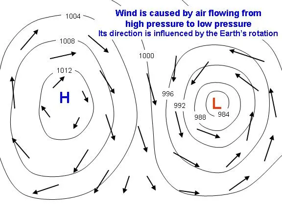
Air pressure is the weight of the atmosphere pressing down on a specific point on the Earth’s surface. When you look at a weather map, you will see "H" for high pressure and "L" for low pressure. High-pressure systems consist of cool, sinking air that spreads outward at the surface. Low-pressure systems are characterized by warm, rising air that pulls surrounding air inward toward the center.
The speed of the wind is determined by the "pressure gradient force," which is the rate at which pressure changes over a specific distance. If the pressure difference between two locations is steep, the wind will blow with much greater force. Meteorologists use isobars—lines connecting points of equal pressure—to visualize this. When isobars are packed closely together, it indicates a strong pressure gradient and, consequently, high wind speeds.
- Isobars close together: Strong, gusty winds.
- Isobars far apart: Calm, light breezes.
- High-pressure centers: Generally clear, stable weather.
- Low-pressure centers: Often associated with clouds, storms, and precipitation.
What are local wind patterns?
While global circulation explains large-scale winds, local geography creates smaller, predictable wind patterns. A classic example is the land and sea breeze cycle. During the day, land heats up much faster than the ocean. The hot air over the land rises, creating a low-pressure area that pulls cooler, denser air from the sea toward the shore. This creates a refreshing sea breeze that many coastal residents enjoy during summer afternoons.
At night, the process reverses because land loses heat much faster than water. The ocean remains warmer than the land, causing air over the water to rise and pulling the cooler air from the land out toward the sea. This is known as a land breeze. Similar effects occur in mountainous regions, where valley breezes blow upslope during the day as mountain peaks heat up, and mountain breezes blow downslope at night as the peaks cool rapidly.
How to measure wind speed and direction
Measuring wind requires two primary pieces of information: velocity and direction. Wind speed is typically measured in miles per hour, kilometers per hour, or knots, while direction is recorded by the compass point from which the wind originates. For example, a "northerly" wind means the air is moving from the north toward the south.
- Use an anemometer to measure wind speed; the spinning cups rotate faster as wind speed increases.
- Observe a wind vane to determine direction; the arrow points into the wind.
- Check the Beaufort Scale to estimate wind speed visually by observing environmental cues like tree movement or wave height.
- Integrate these readings over time to calculate average wind speeds for a specific location.
Common mistakes when tracking wind
One common error is assuming that wind always blows in a straight line from a high-pressure area to a low-pressure area. While the pressure gradient force initiates the movement, friction with the Earth’s surface and the Coriolis effect significantly alter the path of the wind. Near the ground, buildings, trees, and hills create surface roughness that slows the wind and causes it to change direction, a phenomenon known as the boundary layer effect.
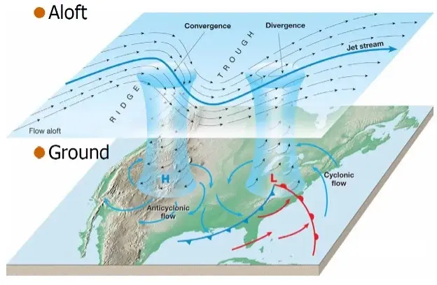
Another mistake is failing to account for altitude. Winds high in the atmosphere, such as the jet stream, move much faster than surface winds because they are unaffected by the friction of the Earth's surface. Beginners often look at surface conditions and incorrectly predict the behavior of weather systems moving at higher altitudes. Always remember that local observations are only a small part of a much larger, three-dimensional atmospheric engine that is constantly shifting based on heat distribution and the rotation of the planet.
Key facts
- Wind is the movement of air caused by differences in atmospheric pressure between two locations.
- Air naturally flows from areas of high pressure toward areas of low pressure to achieve balance.
- The Sun is the primary driver of wind because it heats the Earth's surface unevenly.
- The Coriolis effect, caused by Earth's rotation, deflects wind paths to the right in the Northern Hemisphere.
- Friction from mountains, trees, and buildings slows down wind speeds near the Earth's surface.
- Meteorologists measure wind speed using an anemometer and wind direction using a weather vane.
The bottom line
Wind is essentially nature’s way of balancing the atmosphere. By moving air from high-pressure zones to low-pressure areas, the planet regulates temperature and distributes moisture. Driven by solar heating and influenced by the Earth’s rotation, these air currents dictate global weather patterns. Understanding these dynamics helps us predict storms, harness renewable energy, and navigate the skies effectively, highlighting the constant, invisible motion of our atmosphere.
People also ask
How does the sun create wind?
The sun heats the Earth's surface unevenly due to variations in terrain and cloud cover. Warm air expands and rises, creating a low-pressure zone, while cooler, denser air rushes in to fill the gap.
What is the difference between a breeze and a gale?
The distinction is based on speed as measured by the Beaufort scale. A breeze refers to light to moderate winds, while a gale involves sustained winds ranging from 39 to 54 miles per hour.
Why are winds stronger at higher altitudes?
Air at higher altitudes experiences less friction from the Earth's surface features like hills or buildings. This lack of obstruction allows air masses to move more freely and at higher velocities.
What is the Coriolis effect?
This phenomenon occurs because the Earth rotates on its axis. It causes moving air to curve rather than travel in a straight line, influencing global wind patterns like trade winds.
How do sea breezes work?
During the day, land heats up faster than the ocean, causing air to rise over the land. Cooler air from the sea moves inland to replace it, creating a refreshing daily sea breeze.
Can wind be predicted accurately?
Meteorologists use computer models and satellite data to forecast wind patterns. While short-term predictions are highly accurate, local wind conditions can change rapidly due to sudden temperature shifts or storms.
This answer was created with the help of AI research tools and reference sources. Spotted an error? Let us know — we correct mistakes quickly. See our editorial policy.