What causes tides?
Short answer
Tides are the periodic rise and fall of Earth’s ocean surfaces caused primarily by the gravitational pull of the Moon and the Sun. As Earth rotates, these celestial bodies exert forces that create "bulges" of water on opposite sides of the planet, resulting in the rhythmic coastal water level changes we observe daily.
On this page
Why do tides happen?
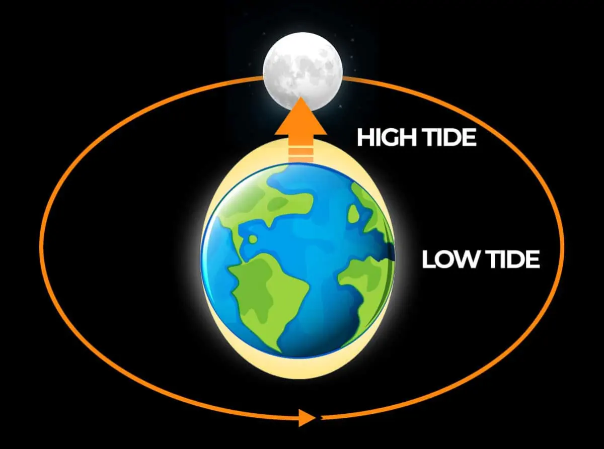
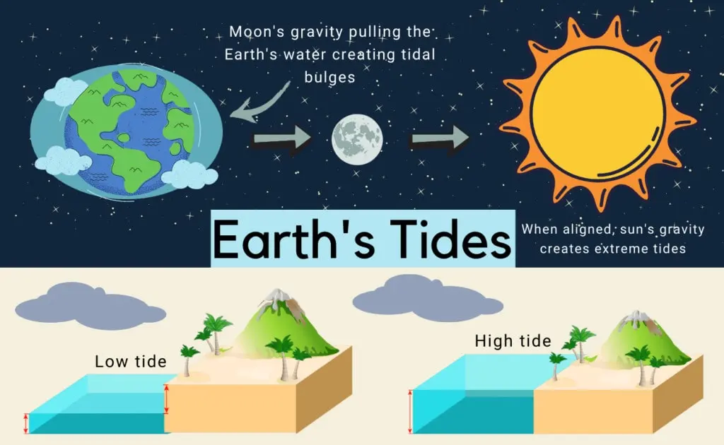
Tides are fundamentally the result of gravity. Because the Moon is relatively close to Earth, its gravitational pull is strong enough to tug on the planet’s oceans. This force creates a tidal bulge on the side of Earth facing the Moon. Simultaneously, a second bulge forms on the opposite side of Earth, caused by the inertia of the water as the planet and Moon orbit their common center of mass.
As Earth rotates on its axis, different locations pass through these bulges. When a coastal area moves into a bulge, the water level rises, creating high tide. As the area rotates out of the bulge, the water level recedes, resulting in low tide. While the Sun also exerts a gravitational pull on Earth, its effect is roughly half that of the Moon because it is significantly farther away.
How does the Moon affect tides?
The Moon is the primary driver of tidal cycles. A full lunar day, or the time it takes for a specific point on Earth to rotate back under the Moon, is approximately 24 hours and 50 minutes. Consequently, most coastal locations experience two high tides and two low tides every lunar day, with the timing shifting by about 50 minutes each day.
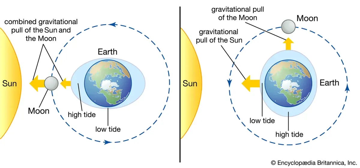
The relationship between the Sun, Moon, and Earth also creates variations in tidal intensity throughout the month:
- Spring Tides: Occur during full and new moons when the Sun, Moon, and Earth align, combining their gravitational forces to produce higher high tides and lower low tides.
- Neap Tides: Occur during the first and third quarter moons when the Sun and Moon are at right angles to each other, partially canceling out their gravitational effects and resulting in less extreme tidal ranges.
How to read a tide chart
Reading a tide chart is essential for activities like fishing, boating, or coastal hiking. These charts provide the predicted times and heights of high and low tides for a specific location. To use one effectively, you must identify your local reference station, as tidal patterns change drastically based on geography, coastline shape, and water depth.
Follow these steps to interpret a standard tide table:
- Locate the specific date and the corresponding high and low tide times.
- Note the height of the tide, which is usually measured relative to a "Mean Lower Low Water" baseline.
- Calculate the tidal range, which is the difference in height between the high tide and the subsequent low tide.
- Check for "slack water," the brief period between tides when the water is still, which is often the safest time for navigation.
Common mistakes when predicting tides
A frequent error is assuming that tide times are universal. Many beginners mistakenly believe that if it is high tide in one city, it must be high tide in a neighboring coastal town. In reality, the complex shape of the ocean floor, the presence of islands, and the configuration of bays can delay or advance the arrival of the tidal bulge by several hours.
Another mistake is ignoring the impact of weather on tidal predictions. While gravity dictates the cycle, atmospheric conditions can significantly alter the actual water level. High-pressure systems can depress sea levels, while strong onshore winds or storm surges can push water toward the coast, causing tides to be much higher than the charts predict. Always check local weather reports alongside your tide tables to ensure accuracy.
Best ways to track tides for beginners
For those new to coastal activities, technology has made tracking tides highly accessible. Numerous mobile applications and websites now provide real-time data and visual graphs that make complex tidal patterns easy to understand at a glance. These tools often include features that allow you to set alerts for high or low tide, ensuring you never get caught in an unexpected rising tide.
If you prefer traditional methods or are in an area without reliable cellular service, consider these options:
- Printed tide calendars: Often available at local bait shops or marinas, these are reliable for planning trips weeks or months in advance.
- Tide clocks: These specialized analog clocks are set to the lunar day and provide a visual representation of whether the tide is currently incoming or outgoing.
- Local observation: Spend time at your specific destination to observe the "tide line" on rocks or pilings, which gives a practical sense of the local tidal range.
Key facts
- Tides are primarily caused by the gravitational pull of the Moon and the Sun on Earth's oceans.
- The Moon has a stronger influence on tides than the Sun because it is much closer to Earth.
- High tides occur on the side of Earth facing the Moon and on the exact opposite side.
- Earth rotates through these tidal bulges, which is why most coastal locations experience two high and two low tides daily.
- Spring tides occur during a full or new moon when the Sun and Moon align, creating the highest tidal range.
- To predict local tides, consult a tide table rather than relying on general rules, as coastline shape significantly alters water movement.
The bottom line
Tides are the rhythmic rise and fall of sea levels driven by the gravitational interaction between Earth, the Moon, and the Sun. While the Moon acts as the primary force, the Sun and local coastal topography also play vital roles. Understanding these patterns is essential for maritime safety and coastal activities, as the timing and height of the water change predictably throughout every lunar cycle.
People also ask
Why do some places have only one high tide per day?
This phenomenon, known as a diurnal tide, occurs due to the complex interaction between the Moon's gravitational pull and the specific shape and depth of the local coastline. Geography can dampen one of the two daily tidal bulges, leaving only a single cycle.
What is a neap tide?
A neap tide occurs when the Sun and Moon are at right angles to each other relative to Earth. During this time, their gravitational forces partially cancel each other out, resulting in a smaller difference between high and low tide.
Do tides affect lakes?
Most small lakes do not have noticeable tides because they lack the massive volume of water required for the Moon's gravity to create a measurable bulge. However, very large bodies of water, such as the Great Lakes, experience tiny tidal changes of only a few centimeters.
How does the Earth's rotation influence tides?
As Earth rotates on its axis, different coastal areas move through the tidal bulges created by the Moon's gravity. This constant motion is the primary reason why high and low tides shift by approximately 50 minutes each day.
Can wind affect tide levels?
Yes, strong winds can push water toward or away from the shore, creating a "storm surge" or "wind tide." This can cause water levels to be significantly higher or lower than what is predicted by gravitational tide tables.
Why are tides important for navigation?
Mariners use tide tables to ensure there is enough water depth to clear the seafloor when entering or leaving harbors. Miscalculating the tide can lead to ships running aground or becoming trapped in shallow channels.
This answer was created with the help of AI research tools and reference sources. Spotted an error? Let us know — we correct mistakes quickly. See our editorial policy.