What are time zones?
Short answer
Time zones are geographic regions that observe a uniform standard time for legal, commercial, and social purposes. They were established to synchronize clocks globally, accounting for Earth’s rotation. By dividing the planet into 24 longitudinal slices, time zones ensure that noon occurs roughly when the sun reaches its highest point in the sky.
On this page
Why do time zones exist?
Before the 19th century, most towns set their clocks based on local solar time. When the sun reached its zenith, it was noon. This caused significant confusion as the Industrial Revolution expanded, particularly for railroads. A train traveling across a country would encounter dozens of different local times, making it nearly impossible to maintain accurate schedules or avoid collisions.
Sir Sandford Fleming, a Scottish-Canadian engineer, proposed a standardized system of time zones in 1876. He suggested dividing the Earth into 24 zones, each representing one hour of the day. This system was formally adopted at the International Meridian Conference in 1884. By anchoring time to the Prime Meridian in Greenwich, England, the world gained a reliable framework for international travel, communication, and commerce.
How are time zones calculated?
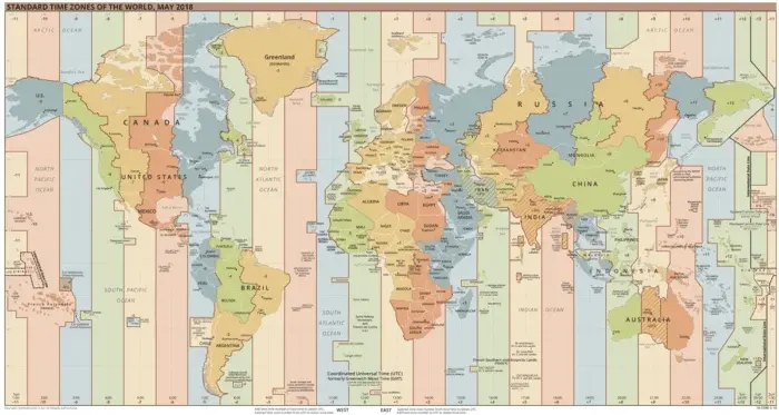
The Earth rotates 360 degrees every 24 hours, meaning it moves 15 degrees of longitude per hour. Theoretically, each time zone spans 15 degrees of longitude, creating a perfect grid around the globe. In practice, however, time zones rarely follow straight lines. Governments often adjust boundaries to align with political borders, state lines, or economic regions.
Several factors influence how these zones are drawn:
- National borders: Countries prefer to keep their entire territory within a single time zone to simplify administration.
- Geographic features: Mountains or islands may be grouped with a specific zone to maintain trade ties.
- Daylight Saving Time: Some regions choose to shift their clocks forward or backward, further complicating the global map.
- Political preference: Large nations, such as China, may mandate a single time zone despite spanning several geographic ones.
How to calculate time differences?
Calculating the time difference between two locations requires identifying their offset from Coordinated Universal Time (UTC). UTC is the primary time standard by which the world regulates clocks and time. Locations to the east of the Prime Meridian are generally ahead of UTC, while locations to the west are behind.
To determine the time in another location, follow these steps:
- Identify the UTC offset for your current location (e.g., UTC-5).
- Identify the UTC offset for your target location (e.g., UTC+1).
- Calculate the total difference by adding or subtracting the offsets.
- Apply this difference to your local time, remembering to account for the date if you cross the International Date Line.
If you are traveling, check the specific offset for your destination, as some regions observe fractional offsets, such as 30 or 45 minutes, rather than full-hour increments.
What is Daylight Saving Time?
Daylight Saving Time (DST) is the practice of advancing clocks by one hour during warmer months so that darkness falls at a later clock time. The concept was popularized during the early 20th century to conserve energy by extending evening daylight. While many countries participate, the start and end dates vary significantly depending on the hemisphere and local legislation.
Not every region observes DST, which can lead to confusion during international meetings. For example, the United States and the United Kingdom often switch on different dates, creating a brief period where the time difference between them changes. When planning global events, always verify if your target region is currently observing standard time or daylight time. Relying on static time zone maps can lead to errors during these transition weeks.
Common mistakes when tracking time zones
One of the most frequent errors is assuming that all time zones shift by exactly one hour. Several countries, including India, Iran, and parts of Australia, utilize half-hour or quarter-hour offsets. Ignoring these fractional differences can result in missing flights or misaligned conference calls. Always use a reliable world clock tool that accounts for specific regional offsets rather than relying on mental math.
Another common mistake involves the International Date Line, which runs through the Pacific Ocean. Crossing this line changes the calendar date, not just the time. Travelers often forget that moving eastward across the line requires subtracting a day, while moving westward requires adding one. Furthermore, failing to account for local DST policies is a frequent pitfall. Always check the specific city or region's current status, as some states or provinces within a country may choose to opt out of DST entirely while their neighbors observe it.
Key facts
- Earth is divided into 24 primary time zones, each theoretically representing one hour of the day.
- The Prime Meridian, located in Greenwich, England, serves as the reference point for Coordinated Universal Time (UTC).
- Time zones are based on lines of longitude, with each zone spanning approximately 15 degrees of the Earth's circumference.
- Many countries adjust their local time by 30 or 45 minutes rather than full hours, creating non-standard offsets.
- Daylight Saving Time is a practice where clocks are advanced by one hour during warmer months to extend evening sunlight.
- The International Date Line is an imaginary line in the Pacific Ocean where the calendar date changes by one day.
The bottom line
Time zones are essential tools that synchronize human activity with the rotation of the Earth. By dividing the globe into segments based on longitude, these systems allow society to maintain consistent schedules despite our planet's curved surface. Understanding how to navigate these offsets is vital for global communication and travel, ensuring that we remain coordinated in an increasingly interconnected world that operates across many different local clocks.
People also ask
Why do some countries have multiple time zones?
Countries that span a large longitudinal distance, such as the United States, Russia, or Australia, use multiple time zones to ensure that local noon aligns with the sun's highest point in the sky. Without these divisions, the sun would rise and set at vastly different times for people living on opposite ends of the same country.
What is the difference between UTC and GMT?
Greenwich Mean Time (GMT) is a time zone based on the rotation of the Earth, while Coordinated Universal Time (UTC) is a high-precision atomic time standard. Although they are often used interchangeably in casual conversation, UTC is the official international benchmark for scientific and aviation timekeeping.
How do I calculate time differences when traveling?
To calculate the time at your destination, identify your current UTC offset and the offset of your arrival city. Subtract your current offset from the destination's offset to determine the hour difference, then add or subtract that number from your current local time.
Why are there more than 24 time zones in use today?
Because of political boundaries and Daylight Saving Time, there are currently over 38 different local time offsets used globally. Some regions choose to align their time with neighboring trade partners rather than their strict geographic longitude to simplify economic activity.
What is a common mistake when crossing time zones?
A common error is failing to account for the International Date Line when traveling across the Pacific Ocean. Travelers often forget that crossing this line requires them to either skip an entire day or repeat one, which can lead to significant scheduling conflicts.
Do all countries observe Daylight Saving Time?
No, many countries near the equator do not observe Daylight Saving Time because their daylight hours remain relatively consistent throughout the year. Additionally, some nations have recently abolished the practice to avoid the health and economic disruptions caused by shifting clocks twice annually.
This answer was created with the help of AI research tools and reference sources. Spotted an error? Let us know — we correct mistakes quickly. See our editorial policy.