What is the prime meridian?
Short answer
The prime meridian is the Earth’s line of zero degrees longitude, serving as the global reference point for time and navigation. It passes through the Royal Observatory in Greenwich, London, effectively dividing the planet into the Eastern and Western Hemispheres. It acts as the starting point for calculating time zones worldwide.
On this page
What is the prime meridian?
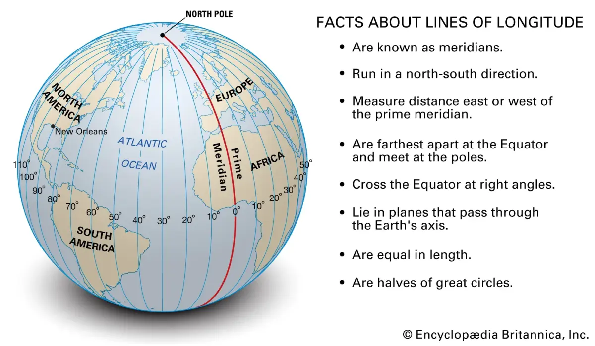
The prime meridian is an imaginary line that runs from the North Pole to the South Pole, marking the starting point for measuring longitude. Unlike the equator, which is defined by the Earth's axis of rotation, the prime meridian is entirely arbitrary. It was internationally agreed upon in 1884 to provide a standardized reference for global navigation and timekeeping.
Before this global consensus, many countries used their own local meridians, such as those passing through Paris or Washington, D.C. This caused significant confusion for international shipping and trade. The adoption of the Greenwich meridian as the universal standard allowed for a synchronized system of longitude, which remains the foundation for modern geography and global positioning systems today.
Why is the prime meridian in Greenwich?
The location of the prime meridian in Greenwich was established during the 1884 International Meridian Conference held in Washington, D.C. Representatives from 25 nations voted to adopt the meridian passing through the Airy Transit Circle at the Royal Observatory in Greenwich, England. This decision was largely influenced by the prominence of British maritime charts and the global reliance on Greenwich Mean Time (GMT) for navigation.
The choice was not without controversy, as France initially abstained from the vote, preferring a neutral meridian. However, the practical benefits of a unified system eventually outweighed national interests. Today, the line is marked by a brass strip and a laser beam at the observatory, attracting thousands of visitors who wish to stand with one foot in the Eastern Hemisphere and the other in the Western Hemisphere.
How does the prime meridian affect time zones?
The prime meridian serves as the anchor for Coordinated Universal Time (UTC). Because the Earth rotates 360 degrees every 24 hours, each hour of time corresponds to 15 degrees of longitude. By using the prime meridian as the zero-point, the world is divided into 24 standard time zones that shift by one hour for every 15 degrees traveled east or west.
- Locate your current longitude on a map.
- Divide your longitude by 15 to determine your offset from UTC.
- Add hours if you are east of the prime meridian.
- Subtract hours if you are west of the prime meridian.
- Adjust for Daylight Saving Time if applicable in your region.
This system ensures that noon occurs roughly when the sun is at its highest point in the sky for most locations within a specific zone. While political boundaries often distort these lines, the mathematical framework remains tied to the Greenwich meridian.
How to find the prime meridian on a map
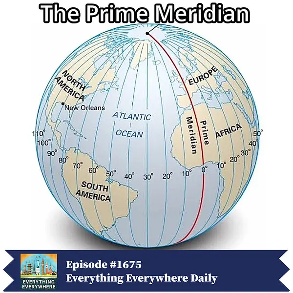
Locating the prime meridian is straightforward if you understand the grid system of latitude and longitude. On most world maps, the prime meridian is the vertical line labeled "0°" that runs directly through Western Europe and Western Africa. It intersects the equator at a point in the Atlantic Ocean known as Null Island, located off the coast of Gabon.
- Identify the vertical axis labeled 0 degrees.
- Follow the line downward through the United Kingdom, France, Spain, Algeria, Mali, Burkina Faso, Togo, and Ghana.
- Note that the line passes through both land and sea, meaning it is not always visible on physical terrain.
- Use digital mapping tools to zoom into the Royal Observatory in Greenwich to see the exact path of the line.
When searching for the line on digital platforms, ensure you are using a standard WGS84 coordinate system. This is the global standard used by GPS devices to ensure accuracy across different software applications.
Common mistakes when using the prime meridian
A frequent error is assuming that the prime meridian is a fixed physical feature that never changes. While the "Greenwich Meridian" is a historical constant, modern satellite measurements have revealed that the Earth's crust is constantly shifting. Consequently, the actual center of the Earth's rotation does not align perfectly with the historical brass line at the observatory, which sits about 100 meters away from the true geodetic meridian.
Another common mistake involves confusing the prime meridian with the International Date Line. While the prime meridian is at 0 degrees longitude, the International Date Line is located at 180 degrees longitude, on the opposite side of the globe. Crossing the prime meridian does not change the calendar date, whereas crossing the International Date Line shifts the date forward or backward by 24 hours. Always verify your orientation when calculating time differences to avoid these common navigation and scheduling errors.
Key facts
- The prime meridian is the imaginary line of 0° longitude that divides the Earth into the Eastern and Western Hemispheres.
- It passes directly through the Royal Observatory in Greenwich, London, serving as the international standard for geographic coordinates.
- Unlike lines of latitude, which are parallel, all meridians converge at the North and South Poles.
- The prime meridian is the reference point for Coordinated Universal Time (UTC), which dictates time zones across the globe.
- To find your longitude, measure the angular distance east or west of the prime meridian, up to 180 degrees in either direction.
- A common mistake is assuming the prime meridian is a physical line; it is a mathematical convention used for navigation and mapping.
The bottom line
The prime meridian is the essential 0° longitude line that anchors our global coordinate system and standardizes timekeeping. By establishing a universal reference point at Greenwich, it allows navigators, pilots, and cartographers to determine precise locations anywhere on Earth. Understanding this meridian is fundamental to geography, as it provides the necessary framework for measuring distance and syncing clocks across different hemispheres and international borders.
People also ask
Why is the prime meridian located in Greenwich?
In 1884, the International Meridian Conference selected Greenwich as the prime meridian because the Royal Observatory was already the site of the most widely used nautical charts. Britain's dominance in global maritime trade at the time made this a practical choice for international navigation.
How does the prime meridian relate to time zones?
Time zones are calculated based on the prime meridian's position, with each 15-degree longitudinal shift representing approximately one hour of time difference. Moving east of the meridian advances time, while moving west results in earlier local times.
Is the prime meridian a straight line?
While it is represented as a straight line on many flat maps, it is technically a great circle that wraps around the entire globe. On a globe, it appears as a vertical arc connecting the North and South Poles through the Greenwich meridian.
What is the opposite of the prime meridian?
The opposite side of the Earth is marked by the 180th meridian, which serves as the approximate path for the International Date Line. Crossing this line generally results in a change of the calendar date by one full day.
Can I visit the prime meridian?
Yes, visitors to the Royal Observatory in Greenwich can stand on a marked line that represents the historical prime meridian. Modern GPS technology reveals that the true geodetic prime meridian is actually about 100 meters east of this historic marker.
Do all countries use the Greenwich meridian as their reference?
Almost all modern global systems, including GPS and international aviation standards, use the IERS Reference Meridian as their primary reference. This standard is slightly offset from the historical Greenwich line to account for the Earth's precise rotation and mass distribution.
This answer was created with the help of AI research tools and reference sources. Spotted an error? Let us know — we correct mistakes quickly. See our editorial policy.